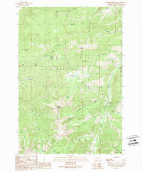
1989 Map of Manhead Mountain
USGS Topo · Published 1989About this map
The Tobacco Root Mountains dominate this high-elevation terrain within the Deerlodge National Forest and Beaverhead National Forest. This 1989 provisional map reveals a landscape defined by its mining history and rugged hydrology, featuring a cluster of prospects and a specific Mine Shaft located near Mill Creek. The small settlement of Mammoth is situated along the South Boulder River in the eastern portion of the quadrangle, serving as a rare point of habitation in a region of steep drainages like Hells Hole and McGovern Creek.
Find a feature on this map
35 named features on this map. Tap any name to fly to it.
Don’t see what you’re looking for? This feature index may not catch every label — zoom into the map to look around manually.
Map Details
Editions of this 1989 Manhead Mountain Map
This is the sole edition of this map. No revisions or reprints were ever made.
Other maps of this area

1888 · Three Forks
USGS Topo · 1:250,000

1893 · Dillon
USGS Topo · 1:250,000

1894 · Three Forks
USGS Topo · 1:250,000

1895 · Three Forks
USGS Topo · 1:250,000

1947 · Bozeman
USGS Topo · 1:250,000

1948 · Bozeman
USGS Topo · 1:250,000

1950 · Jefferson Island
USGS Topo · 1:62,500

1950 · Harrison
USGS Topo · 1:62,500

1955 · Bozeman
USGS Topo · 1:250,000

1955 · Dillon
USGS Topo · 1:250,000