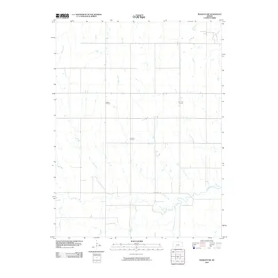
2009 Map of Mankato NW
USGS Topo · Published 2009About this map
Cleveland Cemetery and Shaffer Cemetery anchor this rural landscape in northern Jewell County, where the terrain is defined by a dense network of southward-flowing tributaries. These small waterways, including Norway Creek, Korb Creek, and Oak Creek, drain into the larger White Rock Creek that winds across the southern portion of the map. The road system follows a strict section-line grid, typical of the Great Plains, with White Rock Rd serving as a primary east-west corridor through the countryside. This 2009 survey captures the area's agricultural character, preserved in its lack of concentrated town sites. Genealogists may find value in the specific locations of isolated burial grounds like Olive Hill Cemetery, which stand as landmarks for family histories in this part of Kansas.
Find a feature on this map
14 named features on this map. Tap any name to fly to it.
Don’t see what you’re looking for? This feature index may not catch every label — zoom into the map to look around manually.
Map Details
Editions of this 2009 Mankato NW Map
This is the sole edition of this map. No revisions or reprints were ever made.
Other maps of this area

1894 · Mankato
USGS Topo · 1:125,000

1898 · Superior
USGS Topo · 1:125,000

1955 · Grand Island
USGS Topo · 1:250,000

1955 · Beloit
USGS Topo · 1:250,000

1957 · Grand Island
USGS Topo · 1:250,000

1958 · Grand Island
USGS Topo · 1:250,000

1959 · Beloit
USGS Topo · 1:250,000

1968 · Burr Oak
USGS Topo · 1:24,000

1969 · Mankato
USGS Topo · 1:24,000
1969 · Montrose
USGS Topo · 1:24,000