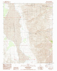
1984 Map of Manly Fall
USGS Topo · Published 1984About this map
Manly Fall sits at the heart of this dramatic 1984 survey, where the steep terrain of the Panamint Range drops sharply into the expansive Panamint Valley. This landscape is defined by its deep, named drainages including Redlands Canyon and Big Horn Canyon, which slice through the arid ridges toward the valley floor. The map documents an area deeply shaped by mining activity, evident in the presence of the Thorndike Mine and Suitcase Mine perched high in the canyons near South Park Canyon. Rare water sources like Redlands Spring and Colter Spring provided critical support for the prospecting and transit that once occurred here. This provisional edition also tracks Wingate Road, the primary north-south artery skirting the eastern edge of the valley, and identifies several borrow pits used for local infrastructure and road maintenance.
Find a feature on this map
17 named features on this map. Tap any name to fly to it.
Don’t see what you’re looking for? This feature index may not catch every label — zoom into the map to look around manually.
Map Details
Editions of this 1984 Manly Fall Map
This is the sole edition of this map. No revisions or reprints were ever made.
Other maps of this area

1908 · Ballarat
USGS Topo · 1:250,000

1913 · Ballarat
USGS Topo · 1:250,000

1915 · Searles Lake
USGS Topo · 1:250,000

1947 · Trona
USGS Topo · 1:250,000

1948 · Trona
USGS Topo · 1:250,000

1948 · Death Valley
USGS Topo · 1:250,000

1949 · Trona
USGS Topo · 1:62,500

1950 · Trona
USGS Topo · 1:62,500

1950 · Manly Peak
USGS Topo · 1:62,500
1951 · Manly Peak
USGS Topo · 1:62,500