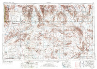
1950 Map of Trona
USGS Topo · Published 1950About this map
Trona serves as the industrial anchor of this desert landscape, where the Trona Railway terminates at the edge of the mineral-rich Searles Lake and Borax Flat. The 1950 era shows a region defined by extraction and remote outposts, with the Argus Range rising sharply to the west and the Panamint Valley stretching toward the east. High-elevation prospecting is evident throughout the canyons, with named workings such as the Ruth Mine, Orlando Mine, and Gold Bottom Mine dotting the slopes. Local water sources like Indian Joe Spring and Bainter Spring provided essential lifelines for these operations. The presence of the Naval Reservation in the southeast corner and the Trona Airport near Valley Wells reflects the growing military and infrastructure footprint in the post-war Mojave Desert.
Find a feature on this map
62 named features on this map. Tap any name to fly to it.
Don’t see what you’re looking for? This feature index may not catch every label — zoom into the map to look around manually.
Map Details
Editions of this 1950 Trona Map
This is the sole edition of this map. No revisions or reprints were ever made.
Historical Maps of Pioneer Point Through Time
7 maps found