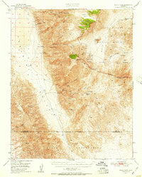
1950 Map of Manly Peak
USGS Topo · Published 1957About this map
Myers Ranch and Russell Camp provide rare points of habitation in this mid-century look at the high desert terrain of the Panamint Range. Located within the boundaries of the Death Valley National Monument and the adjacent Naval Reservation, the area is defined by a rigorous mining history. Evidence of early mineral extraction is scattered throughout, from the Suitcase Mine in the north to the Standard Mine in the southern Slate Range. These operations were often supported by complex infrastructure, including a Dismantled Aerial Cableway near Manly Fall. The landscape is etched with deep drainages like Goler Canyon and South Park Canyon, where essential water sources like Anvil Spring and Sourdough Spring supported prospectors and travelers navigating the high mountain passes, such as Mengel Pass.
Find a feature on this map
41 named features on this map. Tap any name to fly to it.
Don’t see what you’re looking for? This feature index may not catch every label — zoom into the map to look around manually.
Map Details
Editions of this 1950 Manly Peak Map
2 editions found

Other maps of this area

1908 · Furnace Creek
USGS Topo · 1:250,000

1908 · Ballarat
USGS Topo · 1:250,000

1910 · Furnace Creek
USGS Topo · 1:250,000

1913 · Ballarat
USGS Topo · 1:250,000

1915 · Searles Lake
USGS Topo · 1:250,000

1933 · Avawatz Mountains
USGS Topo · 1:250,000

1947 · Trona
USGS Topo · 1:250,000

1948 · Trona
USGS Topo · 1:250,000

1948 · Death Valley
USGS Topo · 1:250,000

1948 · Quail Mountains
USGS Topo · 1:62,500