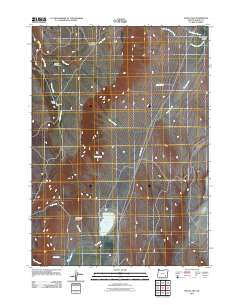
2011 Map of Mann Lake
USGS Topo · Published 2011About this map
Mann Lake serves as a central landmark in this high-desert basin of Harney County, where water sources dictate the placement of human improvements. The map documents scattered ranching infrastructure like Sullivan Corral and the Mann Lake Cabin, positioned near seasonal drainage systems such as Sullivan Creek. The landscape is defined by its arid hydrology, featuring named springs like Strode Springs, Barrel Springs, and Big Springs, which have long been vital for livestock in this remote corner of Oregon.
Find a feature on this map
18 named features on this map. Tap any name to fly to it.
Don’t see what you’re looking for? This feature index may not catch every label — zoom into the map to look around manually.
Map Details
Editions of this 2011 Mann Lake Map
This is the sole edition of this map. No revisions or reprints were ever made.
Other maps of this area

1955 · Adel
USGS Topo · 1:250,000

1957 · Adel
USGS Topo · 1:250,000

1958 · Adel
USGS Topo · 1:250,000

1962 · Adel
USGS Topo · 1:250,000

1968 · Poison Springs
USGS Topo · 1:24,000

1968 · Wildhorse Lake
USGS Topo · 1:24,000

1968 · Big Pasture Creek
USGS Topo · 1:24,000
1981 · Mann Lake
USGS Topo · 1:24,000
1981 · Comegys Lake
USGS Topo · 1:24,000
1981 · Juniper Lake
USGS Topo · 1:24,000