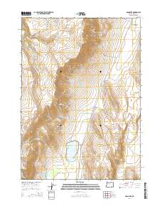
2014 Map of Mann Lake
USGS Topo · Published 2014About this map
Steens Mtn dominates the eastern high desert landscape of Harney County, its massive slopes feeding a network of seasonal drainages and springs. This 2014 survey documents the remote hydrology of the Great Basin, where Mann Lake serves as a primary catchment for water flowing from the western mountain faces. The geography is characterized by high-altitude grazing areas like Paddle Meadows and Sullivan Meadows, while the curiously named Hole in the Ground provides a distinct geological focal point near the lake's western edge. Human passage through this isolation is centered on E Steens Rd, which traces the contours below Stonehouse Canyon. Vital water sources including Big Springs, Strode Springs, and Barrel Springs are mapped with precision, highlighting the critical importance of these features for livestock and wildlife in a region defined by its scarcity of permanent water.
Find a feature on this map
21 named features on this map. Tap any name to fly to it.
Don’t see what you’re looking for? This feature index may not catch every label — zoom into the map to look around manually.
Map Details
Editions of this 2014 Mann Lake Map
This is the sole edition of this map. No revisions or reprints were ever made.
Other maps of this area

1955 · Adel
USGS Topo · 1:250,000

1957 · Adel
USGS Topo · 1:250,000

1958 · Adel
USGS Topo · 1:250,000

1962 · Adel
USGS Topo · 1:250,000

1968 · Poison Springs
USGS Topo · 1:24,000

1968 · Wildhorse Lake
USGS Topo · 1:24,000

1968 · Big Pasture Creek
USGS Topo · 1:24,000
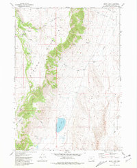
1981 · Mann Lake
USGS Topo · 1:24,000
1981 · Comegys Lake
USGS Topo · 1:24,000
1981 · Juniper Lake
USGS Topo · 1:24,000