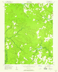
1956 Map of Manry
USGS Topo · Published 1958About this map
The boundary between Sussex and Southampton counties divides this rural landscape, characterized by the winding headwaters of Seacock Swamp and its various tributaries. Small agricultural settlements and crossroads anchor the community, notably around Manry and Cashs Corner, where localized infrastructure like the Manry School and Piney Grove School served the mid-century population. The presence of numerous historical houses of worship, such as Old Elam Church, Union Hill Church, and Hebron Church, suggests a deeply rooted social fabric tied to the land's geography.
Find a feature on this map
26 named features on this map. Tap any name to fly to it.
Don’t see what you’re looking for? This feature index may not catch every label — zoom into the map to look around manually.
Map Details
Editions of this 1956 Manry Map
This is the sole edition of this map. No revisions or reprints were ever made.
Other maps of this area

1919 · Surry
USGS Topo · 1:62,500

1919 · Disputanta
USGS Topo · 1:62,500

1919 · Homeville
USGS Topo · 1:48,000

1920 · Ivor
USGS Topo · 1:62,500

1920 · Homeville
USGS Topo · 1:62,500

1943 · Sebrell
USGS Topo · 1:31,680

1943 · Manry
USGS Topo · 1:31,680

1943 · Littleton
USGS Topo · 1:31,680

1943 · Vicksville
USGS Topo · 1:31,680

1943 · Richmond
USGS Topo · 1:250,000