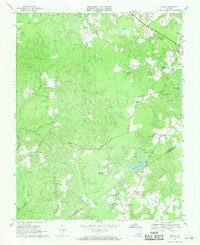
1969 Map of Manry
USGS Topo · Published 1971About this map
The lowland interior of southeastern Virginia is defined here by an intricate drainage system where Seacock Swamp and Seacorrie Swamp meet the Sussex and Southampton county line. This 1969 field-checked survey reveals a landscape of small agricultural clusters and water-powered history, centered on the village of Manry and the crossroad of Barrett Corner. The presence of numerous mill-related water bodies, including Brittles Millpond and Laniers Millpond, suggests a long-standing reliance on local creek systems for timber or grist operations, while the Norfolk and Western line in the northeast corner provided the vital rail link to coastal markets. Several rural congregations serve as local landmarks, such as Hebron Ch near Mill Run and Union Hill Ch to the west. This mapping captures the region before extensive modern development, preserving the locations of the Wakefield Community Hunt Club and several small family-named cemeteries that are essential for genealogical research in this part of the Tidewater.
Find a feature on this map
32 named features on this map. Tap any name to fly to it.
Don’t see what you’re looking for? This feature index may not catch every label — zoom into the map to look around manually.
Map Details
Editions of this 1969 Manry Map
This is the sole edition of this map. No revisions or reprints were ever made.
Other maps of this area

1919 · Surry
USGS Topo · 1:62,500

1919 · Disputanta
USGS Topo · 1:62,500

1919 · Homeville
USGS Topo · 1:48,000

1920 · Ivor
USGS Topo · 1:62,500

1920 · Homeville
USGS Topo · 1:62,500

1943 · Sebrell
USGS Topo · 1:31,680

1943 · Manry
USGS Topo · 1:31,680

1943 · Littleton
USGS Topo · 1:31,680

1943 · Vicksville
USGS Topo · 1:31,680

1943 · Richmond
USGS Topo · 1:250,000