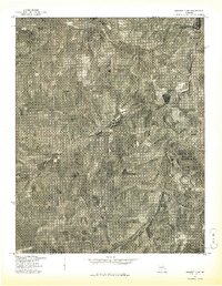
1977 Map of Mansfield NE
USGS Topo · Published 1977About this map
Hartville sits at the northern edge of this Wright County landscape, captured in a 1977 orthophotograph that reveals the intricate patterns of mid-Missouri agriculture and woodland. The Gasconade River winds diagonally across the terrain, its valley floor clearly marked by the concentrated patchwork of cleared fields that follow the water's path. Unlike standard topographic maps, this imagery-based study produced in cooperation with the Soil Conservation Service offers a direct view of the land surface as it appeared in the late 1970s. Researchers can examine the specific density of forest cover and the layout of rural farmsteads and road networks that radiate away from the river banks and the primary settlement of Hartville.
Find a feature on this map
2 named features on this map. Tap any name to fly to it.
Don’t see what you’re looking for? This feature index may not catch every label — zoom into the map to look around manually.
Map Details
Editions of this 1977 Mansfield NE Map
This is the sole edition of this map. No revisions or reprints were ever made.
Other maps of this area

1931 · Manes
USGS Topo · 1:48,000

1941 · Manes
USGS Topo · 1:62,500

1943 · Manes
USGS Topo · 1:62,500

1951 · Norwood
USGS Topo · 1:24,000

1951 · Owens
USGS Topo · 1:24,000

1951 · Mansfield NE
USGS Topo · 1:24,000

1951 · Mansfield NW
USGS Topo · 1:24,000
1951 · Mansfield
USGS Topo · 1:24,000
1951 · Cedar Gap
USGS Topo · 1:24,000

1951 · Mountain Grove
USGS Topo · 1:62,500