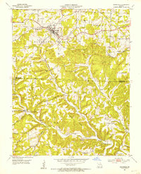
1951 Map of Mansfield
USGS Topo · Published 1953About this map
Mansfield serves as the focal point of this early 1950s survey, situated along the ST Louis - San Francisco railroad. The landscape is defined by a dense network of hollows, including Prairie Hollow, Buzzard Hollow, and Smelter Hollow, which dictated the placement of small rural communities and institutions. Small settlements like Midway and Olathia anchor the southern townships, while a high concentration of country churches and schoolhouses, such as Ashley Ch and Flat Rock Sch, reflect the dispersed nature of the Ozark population during this era. An interesting detail is the Huffman Sch (Abandoned), indicating shifting demographics and the consolidation of rural education. The terrain transitions from the rail-corridor plateau down to Bryant Creek and Dry Creek, illustrating the historical reliance on both the railroad and local watercourses for the region's development.
Find a feature on this map
48 named features on this map. Tap any name to fly to it.
Don’t see what you’re looking for? This feature index may not catch every label — zoom into the map to look around manually.
Map Details
Editions of this 1951 Mansfield Map
3 editions found
Other maps of this area

1936 · Ava
USGS Topo · 1:48,000

1937 · Buckhart
USGS Topo · 1:48,000

1942 · Ava
USGS Topo · 1:62,500

1943 · Buckhart
USGS Topo · 1:62,500

1945 · Ava
USGS Topo · 1:62,500

1945 · Harrison
USGS Topo · 1:250,000

1945 · Buckhart
USGS Topo · 1:62,500

1949 · Harrison
USGS Topo · 1:250,000

1951 · Norwood
USGS Topo · 1:24,000

1951 · Owens
USGS Topo · 1:24,000