
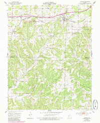
1951 Map of Norwood
USGS Topo · Published 1952About this map
The St Louis San Francisco railroad cuts a straight east-west line through the Missouri Ozarks in the early 1950s, anchoring the community of Norwood. This survey reveals a landscape of concentrated rural infrastructure, where small school districts and cemeteries are tucked into the drainage basins of Dry Creek and Fox Creek. Notable local landmarks like Fairview Sch and Cornelius Sch served the surrounding family farms, while a Quarry near the tracks suggests the local industry supporting the rail line. Moving south toward the boundary of Wright Co Douglas Co, the terrain becomes increasingly dissected, defined by Tick Ridge and Samson Hollow. Numerous small burial grounds, such as Shiloh Cem and Mount Harmon Cem, reflect the generation-to-generation settlement patterns of Clark and Cass townships during this era of mid-century agricultural life.
Find a feature on this map
33 named features on this map. Tap any name to fly to it.
Don’t see what you’re looking for? This feature index may not catch every label — zoom into the map to look around manually.
Map Details
Editions of this 1951 Norwood Map
2 editions found
Other maps of this area

1936 · Ava
USGS Topo · 1:48,000

1937 · Buckhart
USGS Topo · 1:48,000

1942 · Ava
USGS Topo · 1:62,500

1943 · Buckhart
USGS Topo · 1:62,500

1945 · Ava
USGS Topo · 1:62,500

1945 · Harrison
USGS Topo · 1:250,000

1945 · Buckhart
USGS Topo · 1:62,500

1949 · Harrison
USGS Topo · 1:250,000

1951 · Mountain Grove South
USGS Topo · 1:24,000

1951 · Mountain Grove North
USGS Topo · 1:24,000