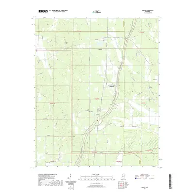
2020 Map of Mantee
USGS Topo · Published 2020About this map
Mantee and Dancy anchor this portion of Webster County, where the modern Natchez Trace Parkway bisects the landscape of north-central Mississippi. The terrain is defined by the headwaters and tributaries of the Big Black River, with Line Creek and Old Field Creek carving through the agricultural and wooded surroundings. Evidence of early community centers remains preserved in the numerous cemeteries scattered across the township lines, including Mount Pleasant Cemetery near the Chickasaw County border and Pisgah Cemetery to the southeast. The survey details the drainage patterns of the Topashaw Canal and the recreation areas surrounding Mantee Lake. For those tracing local history, the map identifies family-named landmarks like Choctaw Ridge and a dense network of rural roads such as Old Cumberland Road and Jack Forrester Road.
Find a feature on this map
81 named features on this map. Tap any name to fly to it.
Don’t see what you’re looking for? This feature index may not catch every label — zoom into the map to look around manually.
Map Details
Editions of this 2020 Mantee Map
This is the sole edition of this map. No revisions or reprints were ever made.
Other maps of this area

1953 · West Point
USGS Topo · 1:250,000

1958 · West Point
USGS Topo · 1:250,000

1959 · Van Vleet
USGS Topo · 1:62,500

1959 · Pheba
USGS Topo · 1:62,500

1963 · West Point
USGS Topo · 1:250,000

1972 · Maben
USGS Topo · 1:24,000

1972 · Atlanta
USGS Topo · 1:24,000

1972 · Sapa
USGS Topo · 1:24,000

1972 · Hohenlinden
USGS Topo · 1:24,000

1972 · Mantee
USGS Topo · 1:24,000