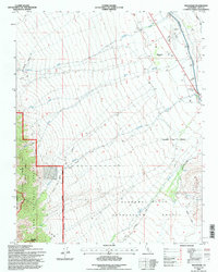
1994 Map of Manzanar
USGS Topo · Published 1997About this map
The Manzanar (Site) is documented in this mid-1990s revision as a place of historical reflection. The map details the infrastructure remaining from this period, including the Cem and a Historical Mon located near the former encampment. The landscape is heavily defined by the movement of water from the Sierra Nevada to the coast, evidenced by the prominent Los Angeles Aqueduct and the Stevens Canal cutting across the eastern plains below the foothills.
Find a feature on this map
21 named features on this map. Tap any name to fly to it.
Don’t see what you’re looking for? This feature index may not catch every label — zoom into the map to look around manually.
Map Details
Editions of this 1994 Manzanar Map
This is the sole edition of this map. No revisions or reprints were ever made.
Other maps of this area

1907 · Mt. Whitney
USGS Topo · 1:125,000

1919 · Mt. Whitney
USGS Topo · 1:125,000

1937 · Mt. Whitney
USGS Topo · 1:125,000

1948 · Fresno
USGS Topo · 1:250,000

1951 · Independence
USGS Topo · 1:62,500

1953 · Mt. Pinchot
USGS Topo · 1:62,500

1955 · Fresno
USGS Topo · 1:250,000

1956 · Fresno
USGS Topo · 1:250,000

1956 · Mount Whitney
USGS Topo · 1:62,500

1958 · Fresno
USGS Topo · 1:250,000