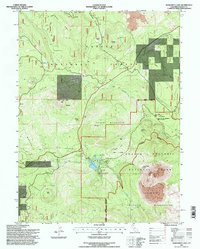
1995 Map of Manzanita Lake
USGS Topo · Published 1997About this map
Lassen Volcanic National Park and the surrounding Lassen National Forest define this landscape dominated by volcanic activity and reforestation efforts. The geological history is evident in features like the Chaos Jumbles and Chaos Crags, which illustrate the area's volatile past. Near the park entrance, the Interagency Fire & Visitor Center and Entrance (Station) serve as the primary access points for the high-altitude recreation area, including sites like Manzanita Lake and the nearby Amphitheater.
Find a feature on this map
40 named features on this map. Tap any name to fly to it.
Don’t see what you’re looking for? This feature index may not catch every label — zoom into the map to look around manually.
Map Details
Editions of this 1995 Manzanita Lake Map
This is the sole edition of this map. No revisions or reprints were ever made.
Other maps of this area

1886 · Lassen Peak
USGS Topo · 1:250,000

1892 · Lassen Peak
USGS Topo · 1:250,000

1894 · Lassen Peak
USGS Topo · 1:250,000

1935 · Burney
USGS Topo · 1:96,000

1935 · Paynes Creek
USGS Topo · 1:96,000

1939 · Burney
USGS Topo · 1:125,000

1939 · Halls Flat
USGS Topo · 1:125,000

1941 · Mineral
USGS Topo · 1:125,000

1955 · Westwood
USGS Topo · 1:250,000

1956 · Lassen Peak
USGS Topo · 1:62,500