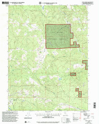
1997 Map of Maple Creek
USGS Topo · Published 2001About this map
Maple Creek and the surrounding Humboldt County wilderness are documented here as they appeared in the late 1990s, characterized by a network of private ranches and high-elevation clearings. Significant family-named holdings such as Russ Ranch, Carson Ranch, and Rock Ranch are spaced across the drainage basins of Redwood Creek and the Mad River. The landscape is defined by its transition from the dense timber of the Six Rivers National Forest to isolated open spaces like Murphy Meadow and High Prairie. A single Substation and a Quarry near Maple Creek Road indicate the sparse infrastructure supporting this rural mountain community. To the north, the settlement at Fernwood sits near the headwaters of Canon Creek, while southern landmarks like Snow Camp Mtn and Pardee Creek highlight the significant relief and complex hydrology of this Northern California terrain.
Find a feature on this map
29 named features on this map. Tap any name to fly to it.
Don’t see what you’re looking for? This feature index may not catch every label — zoom into the map to look around manually.
Map Details
Editions of this 1997 Maple Creek Map
This is the sole edition of this map. No revisions or reprints were ever made.
Other maps of this area

1914 · Pilot Creek
USGS Topo · 1:62,500

1915 · Big Bar and Vicinity
USGS Topo · 1:250,000

1922 · Korbel
USGS Topo · 1:62,500

1922 · China Flat
USGS Topo · 1:62,500

1922 · Kneeland
USGS Topo · 1:62,500

1945 · Blue Lake
USGS Topo · 1:62,500

1950 · Iaqua Buttes
USGS Topo · 1:62,500

1951 · Pilot Creek
USGS Topo · 1:62,500

1951 · Blue Lake
USGS Topo · 1:62,500

1952 · Willow Creek
USGS Topo · 1:62,500