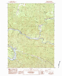
1984 Map of Mapleton
USGS Topo · Published 1984About this map
The Siuslaw River carves a winding path through this portion of the Siuslaw National Forest in Lane County, Oregon. In the mid-1980s, the area’s identity was defined by the intersection of river transport, timber, and the Southern Pacific railroad. Mapleton serves as the primary hub, where industrial infrastructure like a Substation and Steel Tower Transmission Line meet community spaces such as the Athletic Fields. To the east, the small settlement of Swisshome and the historic location of Nekoma sit along the riverbanks, reflecting the dispersed nature of habitation along the narrow valley floor.
Find a feature on this map
57 named features on this map. Tap any name to fly to it.
Don’t see what you’re looking for? This feature index may not catch every label — zoom into the map to look around manually.
Map Details
Editions of this 1984 Mapleton Map
This is the sole edition of this map. No revisions or reprints were ever made.
Other maps of this area

1918 · Mapleton
USGS Topo · 1:48,000

1919 · Earl
USGS Topo · 1:48,000

1940 · Mapleton
USGS Topo · 1:62,500

1941 · Blachly
USGS Topo · 1:62,500

1942 · Blachly
USGS Topo · 1:62,500

1942 · Roman Nose Mtn
USGS Topo · 1:62,500

1943 · Goodwin Peak
USGS Topo · 1:62,500

1945 · Mapleton
USGS Topo · 1:62,500

1945 · Roman Nose Mtn
USGS Topo · 1:62,500

1953 · Salem
USGS Topo · 1:250,000