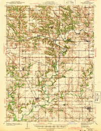
1943 Map of Maquon
USGS Topo · Published 1943About this map
The Spoon River meanders through this portion of Knox County, defining a landscape shaped by agricultural drainage and early industrial extraction. During the early 1940s, the region was a crossroads of major rail lines, including the Atchison Topeka and Santa Fe and the Chicago Burlington and Quincy, which supported small agrarian hubs like Maquon, Yates City, and Dahinda. The map reveals the early footprint of the Strip Mine in the north and the Knoxville Mine near Court Creek, illustrating the transition toward large-scale surface mining. For local historians, the sheet preserves a dense network of rural infrastructure, from family burial grounds like Van Gilder Cem and Mackey Cem to numerous district schools such as White Oak Sch and Egypt Sch, many of which served dispersed farming communities that have since consolidated.
Find a feature on this map
83 named features on this map. Tap any name to fly to it.
Don’t see what you’re looking for? This feature index may not catch every label — zoom into the map to look around manually.
Map Details
Editions of this 1943 Maquon Map
2 editions found
Other maps of this area

1912 · Canton
USGS Topo · 1:62,500

1915 · Avon
USGS Topo · 1:62,500

1925 · Galesburg
USGS Topo · 1:62,500

1927 · Galesburg
USGS Topo · 1:62,500

1930 · Glasford
USGS Topo · 1:62,500

1931 · Galva
USGS Topo · 1:48,000

1940 · Galva
USGS Topo · 1:62,500

1941 · Maquon
USGS Topo · 1:62,500

1943 · Maquon
USGS Topo · 1:62,500

1944 · Galva
USGS Topo · 1:62,500