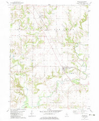
1982 Map of Maquon
USGS Topo · Published 1983About this map
The Spoon River meanders across this section of Knox County, defining a landscape of alluvial bottoms and upland ridges. In the early 1980s, the village of Maquon serves as a primary hub along the Burlington Northern railroad, while Gilson sits to the northwest near the confluence of Haw Creek and Little Haw Creek. This survey is particularly rich for genealogical research, documenting numerous small family and community burial grounds such as McAllister Cem, Thurman Cem, and Harshbarger Cem. The terrain is marked by traditional land use, including a Gravel Pit and the Clark Chapel church, while natural water features like Horseshoe Lake and Hickory Creek provide insight into the local drainage patterns that influenced original settlement locations.
Find a feature on this map
27 named features on this map. Tap any name to fly to it.
Don’t see what you’re looking for? This feature index may not catch every label — zoom into the map to look around manually.
Map Details
Editions of this 1982 Maquon Map
This is the sole edition of this map. No revisions or reprints were ever made.
Other maps of this area

1912 · Canton
USGS Topo · 1:62,500

1915 · Avon
USGS Topo · 1:62,500

1925 · Galesburg
USGS Topo · 1:62,500

1927 · Galesburg
USGS Topo · 1:62,500

1941 · Maquon
USGS Topo · 1:62,500

1943 · Maquon
USGS Topo · 1:62,500

1944 · Avon
USGS Topo · 1:62,500

1958 · Burlington
USGS Topo · 1:250,000

1961 · Burlington
USGS Topo · 1:250,000

1963 · Burlington
USGS Topo · 1:250,000