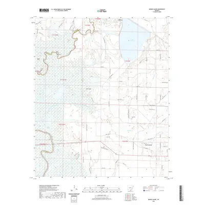
2020 Map of Marais Saline
USGS Topo · Published 2020About this map
Marais Saline characterizes this corner of Southeast Arkansas, where the winding Saline R creates a complex network of sloughs, islands, and backwaters. The terrain is defined by its low-lying wetlands, featuring named features like Horton Island and the distinctive bend known as Round Turn. In the northeastern portion of the map, Stillions sits near the expansive waters of Lake Georgia-Pacific, which dominates the landscape along with numerous drainage systems including Miller Br and Carroll Slough. This environment has historically dictated the settlement patterns of Bradley and Ashley Counties, as seen in the scattered rural road networks like Arkadelphia Cemetery Rd. Local history and genealogy interests are centered around Arkadelphia Cem and the small residential pockets that persist along the ridges, such as Gravel Ridge, providing a clear view of the area's geography and drainage before it transitions into the larger river systems of the region.
Find a feature on this map
67 named features on this map. Tap any name to fly to it.
Don’t see what you’re looking for? This feature index may not catch every label — zoom into the map to look around manually.
Map Details
Editions of this 2020 Marais Saline Map
This is the sole edition of this map. No revisions or reprints were ever made.
Other maps of this area

1934 · Ingalls
USGS Topo · 1:48,000

1934 · Felsenthal
USGS Topo · 1:62,500

1937 · Felsenthal
USGS Topo · 1:62,500

1937 · Ingalls
USGS Topo · 1:62,500

1938 · Felsenthal
USGS Topo · 1:62,500

1939 · Felsenthal
USGS Topo · 1:62,500

1939 · Ingalls
USGS Topo · 1:62,500

1953 · Greenwood
USGS Topo · 1:250,000

1953 · El Dorado
USGS Topo · 1:250,000

1956 · Greenwood
USGS Topo · 1:250,000