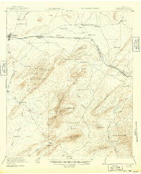
1921 Map of Marathon
USGS Topo · Published 1949About this map
The Southern Pacific System tracks define the northern corridor of this Trans-Pecos landscape, linking the ranching hub of Marathon to the settlement of Haymond. Surveyed in the early 1920s, the map reveals a remote territory organized around isolated homesteads and family ranches, including the Old Beckley Place, Gages Lightning Ranch, and the Old Edith Lochhausen Place. These outposts are scattered across a complex terrain of basins and ridges, including the Peña Blanca Mountains and the distinctively named Hells Half Acre.
Find a feature on this map
48 named features on this map. Tap any name to fly to it.
Don’t see what you’re looking for? This feature index may not catch every label — zoom into the map to look around manually.
Map Details
Editions of this 1921 Marathon Map
2 editions found

Other maps of this area

1917 · Santiago Peak
USGS Topo · 1:62,500

1917 · Hood Spring
USGS Topo · 1:62,500

1918 · Bone Spring
USGS Topo · 1:125,000

1918 · Hood Spring
USGS Topo · 1:62,500

1918 · Dove Mountain
USGS Topo · 1:62,500

1918 · Santiago Peak
USGS Topo · 1:62,500

1920 · Longfellow
USGS Topo · 1:125,000

1920 · Monument Spring
USGS Topo · 1:62,500

1920 · Marathon
USGS Topo · 1:62,500

1921 · Monument Spring
USGS Topo · 1:62,500