
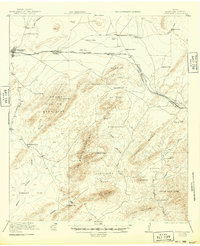
1921 Map of Marathon
USGS Topo · Published 1921About this map
Marathon serves as the primary hub for this West Texas landscape, which is defined by a dense concentration of early 20th-century family ranch sites and homesteads. The Southern Pacific System and the Galveston Harrisburg and San Antonio railroad lines provide the structural backbone for the region, connecting isolated settlements like Haymond and Warwick. Local life and education are anchored at the Warwick School, while the surrounding terrain is heavily partitioned into family-named locations such as the Old Beckley Place, McFarland Place, and Shoemake Place.
Find a feature on this map
53 named features on this map. Tap any name to fly to it.
Don’t see what you’re looking for? This feature index may not catch every label — zoom into the map to look around manually.
Map Details
Editions of this 1921 Marathon Map
2 editions found
Other maps of this area

1917 · Santiago Peak
USGS Topo · 1:62,500

1917 · Hood Spring
USGS Topo · 1:62,500

1918 · Bone Spring
USGS Topo · 1:125,000

1918 · Hood Spring
USGS Topo · 1:62,500

1918 · Dove Mountain
USGS Topo · 1:62,500

1918 · Santiago Peak
USGS Topo · 1:62,500

1920 · Longfellow
USGS Topo · 1:125,000

1920 · Monument Spring
USGS Topo · 1:62,500

1920 · Marathon
USGS Topo · 1:62,500

1921 · Monument Spring
USGS Topo · 1:62,500