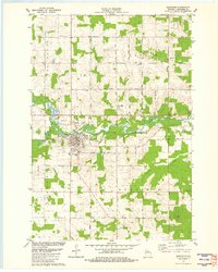
1981 Map of Marathon
USGS Topo · Published 1982About this map
The winding Big Rib River anchors this central Wisconsin landscape, carving a wide valley floor through the township boundaries of Rib Falls, Stettin, Cassel, and Marathon. The primary settlement of Marathon (Marathon City) is concentrated south of the river, where a grid of streets surrounds St Marys Cem and the local High Sch. The community's early infrastructure is evidenced by the presence of a Sew Disp, Water Tank, and municipal Wells located along the riverbank.
Find a feature on this map
46 named features on this map. Tap any name to fly to it.
Don’t see what you’re looking for? This feature index may not catch every label — zoom into the map to look around manually.
Map Details
Editions of this 1981 Marathon Map
This is the sole edition of this map. No revisions or reprints were ever made.
Other maps of this area

1899 · Wausau
USGS Topo · 1:125,000

1902 · Wausau
USGS Topo · 1:125,000

1902 · Marathon
USGS Topo · 1:125,000

1951 · Merrill
USGS Topo · 1:48,000

1951 · Hamburg
USGS Topo · 1:48,000

1953 · Wausau
USGS Topo · 1:48,000

1953 · Marathon
USGS Topo · 1:48,000

1954 · Iron Mountain
USGS Topo · 1:250,000

1955 · Green Bay
USGS Topo · 1:250,000

1959 · Iron Mountain
USGS Topo · 1:250,000