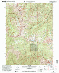
2001 Map of Marble Mountain
USGS Topo · Published 2004About this map
The Marble Mountains define this high-elevation landscape within the Klamath National Forest, where steep ridgelines and glacial basins create a complex network of alpine lakes and seasonal camps. This 2001 revision reveals a wilderness area preserved for backcountry travel, centered around Marble Mountain and the dark silhouette of Black Marble Mountain. The drainage patterns are defined by the Scott River and Wooley Creek, with numerous smaller tributaries like Red Rock Creek carving deep into the terrain. Remote outposts such as Ananias Camp and Whisky Camp highlight the area's history of packing and forest management. The inclusion of the Pacific Crest National Scenic Trail and the Klamath Wild and Scenic River designation reflects late 20th-century conservation priorities, protecting a landscape dotted with evocative landmarks like Man Eaten Lake and Kings Castle.
Find a feature on this map
53 named features on this map. Tap any name to fly to it.
Don’t see what you’re looking for? This feature index may not catch every label — zoom into the map to look around manually.
Map Details
Editions of this 2001 Marble Mountain Map
This is the sole edition of this map. No revisions or reprints were ever made.
Other maps of this area

1914 · Seiad
USGS Topo · 1:125,000

1922 · Seiad
USGS Topo · 1:125,000

1948 · Weed
USGS Topo · 1:250,000

1950 · Weed
USGS Topo · 1:250,000

1955 · Sawyers Bar
USGS Topo · 1:62,500

1955 · Ukonom Lake
USGS Topo · 1:62,500

1955 · Scott Bar
USGS Topo · 1:62,500

1955 · Forks of Salmon
USGS Topo · 1:62,500

1958 · Weed
USGS Topo · 1:250,000

1963 · Weed
USGS Topo · 1:250,000