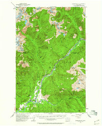
1953 Map of Marblemount
USGS Topo · Published 1960About this map
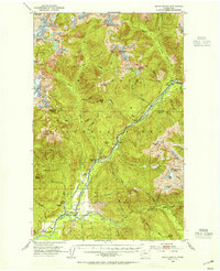
The Skagit River corridor in the mid-1950s served as a critical industrial and transport artery within the Mount Baker National Forest. This survey captures the transition of the region's infrastructure, most notably the Seattle City Railroad (Abandoned), which provided access to the upper reaches of the valley. While the railroad is noted as abandoned, its footprint remains visible through a series of named sidings including Bacon Creek Siding, Jennings Siding, and Sky Creek Siding, tracing a path toward Newhalem. At the confluence of the river and the Cascade River, the settlement of Marblemount appears as a local hub, supported by the State Fish Hatchery and proximity to the Skagit Talc Mine. The landscape is defined by high peaks such as Mt Despair and Mt Triumph, which overlook a network of high-altitude lakes like the Thornton Lakes and Blum Lakes.
Find a feature on this map
56 named features on this map. Tap any name to fly to it.
Don’t see what you’re looking for? This feature index may not catch every label — zoom into the map to look around manually.
Map Details
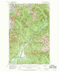
Editions of this 1953 Marblemount Map
3 editions found
Other maps of this area

1899 · Glacier Peak
USGS Topo · 1:125,000

1899 · Stillaguamish
USGS Topo · 1:125,000

1901 · Glacier Peak
USGS Topo · 1:125,000

1901 · Stilaguamish
USGS Topo · 1:125,000

1909 · Mt Baker
USGS Topo · 1:192,000

1915 · Mt. Baker
USGS Topo · 1:250,000
1952 · Lake Shannon
USGS Topo · 1:62,500
1953 · Mt Shuksan
USGS Topo · 1:62,500
1953 · Marblemount
USGS Topo · 1:62,500
1953 · Mt Challenger
USGS Topo · 1:62,500