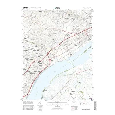
2016 Map of Marcus Hook
USGS Topo · Published 2016About this map
The industrial and residential corridors of Chester and Marcus Hook dominate the northern banks of the Delaware River in this detailed 2016 study. The landscape reflects centuries of development, where established settlements like Aston Mills and Village Green give way to the dense urban grid of Upland and Parkside. This map captures the complex tri-state boundary where Pennsylvania, Delaware, and New Jersey meet amidst the water, highlighting maritime navigation markers such as the Chester Range and Marcus Hook Range.
Find a feature on this map
194 named features on this map. Tap any name to fly to it.
Don’t see what you’re looking for? This feature index may not catch every label — zoom into the map to look around manually.
Map Details
Editions of this 2016 Marcus Hook Map
This is the sole edition of this map. No revisions or reprints were ever made.
Other maps of this area

1890 · Salem
USGS Topo · 1:62,500

1894 · Chester
USGS Topo · 1:62,500

1896 · Chester
USGS Topo · 1:62,500

1898 · Salem
USGS Topo · 1:62,500

1898 · Chester
USGS Topo · 1:62,500
1901 · Camden
USGS Topo · 1:125,000

1901 · West Chester
USGS Topo · 1:62,500

1904 · West Chester
USGS Topo · 1:62,500

1904 · Wilmington
USGS Topo · 1:62,500

1906 · Wilmington
USGS Topo · 1:62,500