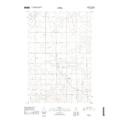
2018 Map of Marengo
USGS Topo · Published 2018About this map
Marengo sits at the heart of this Northwoods landscape, where the confluence of the Marengo River and Brunsweiler River shapes the local geography. The settlement patterns reflect a legacy of rural development in Ashland County, with the smaller clusters of Minersville and North York positioned along established transit corridors. The area is defined by a dense network of watercourses, including Trout Brook, Billy Creek, and Hunts Creek, which traverse the undulating terrain toward the northern lowlands. Local history is anchored by sites like the Maple Grove Cemetery and numerous family-named roads such as Silas Blackman Road and Charles Johnson Road, marking the footprints of early residents. The northeastern corner is punctuated by Moonshine Lake, while the land is divided into a grid of section lines and township boundaries that reveal the systematic surveying of this Wisconsin timber and river country.
Find a feature on this map
66 named features on this map. Tap any name to fly to it.
Don’t see what you’re looking for? This feature index may not catch every label — zoom into the map to look around manually.
Map Details
Editions of this 2018 Marengo Map
This is the sole edition of this map. No revisions or reprints were ever made.
Other maps of this area

1942 · Ashland
USGS Topo · 1:48,000

1942 · Mellen
USGS Topo · 1:48,000

1942 · Marengo
USGS Topo · 1:48,000

1943 · Odanah
USGS Topo · 1:48,000

1945 · Odanah
USGS Topo · 1:48,000

1945 · Marengo
USGS Topo · 1:48,000

1945 · Mellen
USGS Topo · 1:48,000

1947 · Ashland
USGS Topo · 1:48,000

1953 · Ashland
USGS Topo · 1:250,000
1956 · Mellen
USGS Topo · 1:24,000