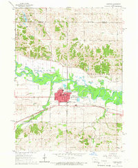
1965 Map of Marengo
USGS Topo · Published 1966About this map
The Iowa River meanders across the central landscape of this 1960s Iowa County survey, defining the industrial and agricultural character of Marengo. The town serves as a significant hub for transport and education, anchored by the Chicago Rock Island and Pacific railroad and facilities like Marengo High Sch and the Iowa Valley Sch. The settlement pattern reflects a stable mid-century community, with the town's grid organized around the Courthouse and Post Office, while essential services like the Hospital and various municipal Sewage Disposal Ponds are situated on the periphery near the riverbanks.
Find a feature on this map
48 named features on this map. Tap any name to fly to it.
Don’t see what you’re looking for? This feature index may not catch every label — zoom into the map to look around manually.
Map Details
Editions of this 1965 Marengo Map
This is the sole edition of this map. No revisions or reprints were ever made.
Other maps of this area

1888 · Amana
USGS Topo · 1:62,500

1889 · Amana
USGS Topo · 1:62,500

1891 · Oxford
USGS Topo · 1:62,500

1894 · Oxford
USGS Topo · 1:62,500

1899 · Amana
USGS Topo · 1:62,500

1903 · Fairfax
USGS Topo · 1:125,000

1954 · Des Moines
USGS Topo · 1:250,000

1956 · Des Moines
USGS Topo · 1:250,000

1957 · Des Moines
USGS Topo · 1:250,000

1958 · Davenport
USGS Topo · 1:250,000