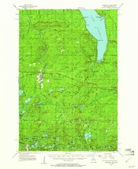
1955 Map of Marenisco
USGS Topo · Published 1961About this map
Marenisco serves as a central hub within the Ottawa National Forest, where the industrial legacy of the Upper Peninsula is written across the landscape. The Chicago and North Western railway cuts through the territory, supporting a timber and transport economy evidenced by the Marenisco Lookout Tower and Copps Lookout Tower that monitored these woods. Further north, the southern reaches of Lake Gogebic dominate the terrain, featuring Gogebic Lake State Park and the settlement of White City along its eastern shore.
Find a feature on this map
115 named features on this map. Tap any name to fly to it.
Don’t see what you’re looking for? This feature index may not catch every label — zoom into the map to look around manually.
Map Details
Editions of this 1955 Marenisco Map
3 editions found
Other maps of this area

1939 · Trout Lake
USGS Topo · 1:48,000

1939 · Winchester
USGS Topo · 1:48,000

1946 · Winchester
USGS Topo · 1:48,000

1946 · Star Lake
USGS Topo · 1:48,000

1946 · Trout Lake
USGS Topo · 1:48,000

1949 · Trout Lake
USGS Topo · 1:48,000

1950 · Star Lake
USGS Topo · 1:48,000

1952 · Thayer
USGS Topo · 1:62,500

1955 · Marenisco
USGS Topo · 1:62,500

1955 · Starlake
USGS Topo · 1:62,500