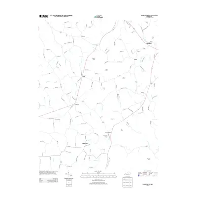
2013 Map of Maretburg
USGS Topo · Published 2013About this map
Maretburg and Ottawa anchor this portion of Rockcastle County, characterized by a series of prominent knobs and a dense network of local roads that trace the winding creek valleys. The landscape is defined by the high ground of Backbone Ridge and individual peaks like Purcell Knob and Marler Knob, which rise above the drainages of Little Negro Cr and Brushy Cr. Small settlements such as Level Green, Willailla, and Spiro are connected by namesake thoroughfares like Maretburg Cemetery Rd and Ottawa School Rd, reflecting the community-oriented infrastructure of the early 21st century. Notable water sources including Double Springs and Owens Spring point to the area's natural hydrology, while landmarks like Friendship Knob indicate the cultural significance of the local topography.
Find a feature on this map
122 named features on this map. Tap any name to fly to it.
Don’t see what you’re looking for? This feature index may not catch every label — zoom into the map to look around manually.
Map Details
Editions of this 2013 Maretburg Map
This is the sole edition of this map. No revisions or reprints were ever made.
Other maps of this area

1893 · London
USGS Topo · 1:125,000

1897 · London
USGS Topo · 1:125,000

1935 · Somerset
USGS Topo · 1:62,500

1952 · Crab Orchard
USGS Topo · 1:24,000

1952 · Billows
USGS Topo · 1:24,000

1952 · Shopville
USGS Topo · 1:24,000

1952 · Woodstock
USGS Topo · 1:24,000

1953 · Maretburg
USGS Topo · 1:24,000

1953 · Wildie
USGS Topo · 1:24,000
1953 · Brodhead
USGS Topo · 1:24,000