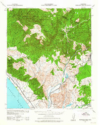
1954 Map of Margarita Peak
USGS Topo · Published 1964About this map
Camp Joseph H Pendleton dominates the coastal and interior landscape of this region during the early 1940s, a period of significant military expansion in Southern California. The topography is defined by the sharp rise of the Santa Margarita Mountains, reaching a high point at Margarita Pk and Roblar. A network of family-held lands like Johnson Ranch, Lattermore Ranch, and Ferndale Ranch are scattered throughout the rugged canyons, illustrating the transition from private ranching to military and forestry management within the Cleveland National Forest.
Find a feature on this map
56 named features on this map. Tap any name to fly to it.
Don’t see what you’re looking for? This feature index may not catch every label — zoom into the map to look around manually.
Map Details
Editions of this 1954 Margarita Peak Map
This is the sole edition of this map. No revisions or reprints were ever made.
Other maps of this area

1893 · Oceanside
USGS Topo · 1:62,500

1893 · Escondido
USGS Topo · 1:62,500

1898 · Oceanside
USGS Topo · 1:62,500

1901 · Southern California Sheet No. 1
USGS Topo · 1:250,000

1901 · Elsinore
USGS Topo · 1:125,000

1901 · Escondido
USGS Topo · 1:62,500

1901 · Oceanside
USGS Topo · 1:62,500

1901 · San Luis Rey
USGS Topo · 1:125,000

1902 · Capistrano
USGS Topo · 1:125,000

1902 · Corona
USGS Topo · 1:125,000
Featured Places
- Oceanside, CA
- Fallbrook, CA
- Marine Corps Base Camp Pendleton, CA
- Santa Margarita Groves, CA
- De Luz Heights, CA