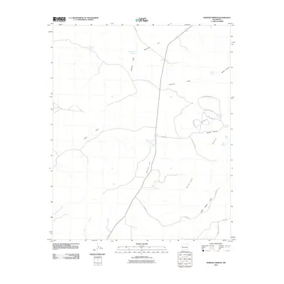
2010 Map of Mariano Springs
USGS Topo · Published 2010About this map
Mariano Springs provides a rare perennial water source in this arid landscape, situated at the base of Mariano Hill. The 2010 geography is defined by a sophisticated network of resource management, where numerous tanks such as Franklin Tank, Dudley Tank, and Marshall Tank capture runoff across the high mesas and draws. This pattern of drainage is evident in the descent of Dudley Canyon and Wyche Canyon, which channel seasonal water from the eastern plateau. Navigation in this part of Catron County relies on a grid of modern and traditional routes, including Starfire Dr and Escondido Vista Dr, alongside named trails like Canyon Crossing Trl. The map illustrates the survival of ranching infrastructure and the strategic importance of ephemeral waterways like Lopez Draw and Wilbur Wadley Draw in the New Mexico high desert.
Find a feature on this map
28 named features on this map. Tap any name to fly to it.
Don’t see what you’re looking for? This feature index may not catch every label — zoom into the map to look around manually.
Map Details
Editions of this 2010 Mariano Springs Map
This is the sole edition of this map. No revisions or reprints were ever made.
Other maps of this area

1954 · Saint Johns
USGS Topo · 1:250,000

1957 · Saint Johns
USGS Topo · 1:250,000

1958 · Saint Johns
USGS Topo · 1:250,000

1962 · Saint Johns
USGS Topo · 1:250,000

1967 · Omega
USGS Topo · 1:24,000

1967 · Mariano Springs
USGS Topo · 1:24,000

1967 · Adams Diggings
USGS Topo · 1:24,000

1967 · Veteado Mountain
USGS Topo · 1:24,000

1967 · Quemado
USGS Topo · 1:24,000
1967 · Techado
USGS Topo · 1:24,000