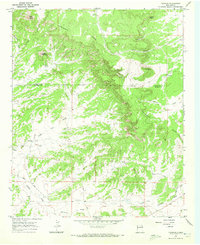
1967 Map of Techado
USGS Topo · Published 1972About this map
The Continental Divide snakes across this high-altitude landscape in western New Mexico, marking the boundary between Valencia and Catron Counties. In this high desert terrain during the late 1960s, water sources like Hogeye Spring and Lathert Well were vital to the livestock operations scattered throughout the region. Isolated outposts such as Towner Ranch, Browns Ranch, and Davis Ranch represent the ranching economy of the era, while the small settlement of Techado sits near the eastern edge of the quadrangle.
Find a feature on this map
25 named features on this map. Tap any name to fly to it.
Don’t see what you’re looking for? This feature index may not catch every label — zoom into the map to look around manually.
Map Details
Editions of this 1967 Techado Map
2 editions found
Other maps of this area

1954 · Saint Johns
USGS Topo · 1:250,000

1957 · Saint Johns
USGS Topo · 1:250,000

1958 · Saint Johns
USGS Topo · 1:250,000

1962 · Saint Johns
USGS Topo · 1:250,000

1967 · Mariano Springs
USGS Topo · 1:24,000

1967 · Chimney Hill
USGS Topo · 1:24,000

1967 · Adams Diggings
USGS Topo · 1:24,000

1967 · Veteado Mountain
USGS Topo · 1:24,000
1967 · Cerro Pomo
USGS Topo · 1:24,000

1972 · Tejana Mesa
USGS Topo · 1:24,000