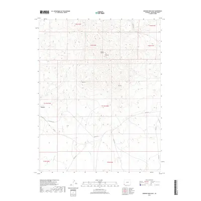
2019 Map of Mariano Wash East
USGS Topo · Published 2019About this map
Sleeping Ute Mtn dominates the northern landscape of this Montezuma County region, with the distinctive geological profiles of The Knees, West Toe, and East Toe rising above the surrounding high desert. The settlement of Mariano sits at the intersection of several significant local routes, including Old Indian Rte 201 and Aneth Rd, reflecting the enduring transit patterns of the Ute Mountain Ute Reservation. This arid environment is defined by its drainage network, where the seasonal waters of Mariano Wash and Aztec Wash have carved deep paths toward the southwest. The presence of numerous designated Indian Routes, such as Indian Rte 237 and Indian Rte 238, highlights the modern infrastructure managed by the Bureau of Indian Affairs in this part of southwestern Colorado.
Find a feature on this map
25 named features on this map. Tap any name to fly to it.
Don’t see what you’re looking for? This feature index may not catch every label — zoom into the map to look around manually.
Map Details
Editions of this 2019 Mariano Wash East Map
This is the sole edition of this map. No revisions or reprints were ever made.
Other maps of this area

1956 · Cortez
USGS Topo · 1:250,000

1957 · Moqui SW
USGS Topo · 1:24,000

1957 · Moqui SE
USGS Topo · 1:24,000

1958 · Sentinel Peak NW
USGS Topo · 1:24,000

1958 · Cortez SW
USGS Topo · 1:24,000

1958 · Sentinel Peak NE
USGS Topo · 1:24,000

1958 · Cortez
USGS Topo · 1:250,000

1959 · Cortez
USGS Topo · 1:250,000

1962 · Cortez
USGS Topo · 1:250,000

1966 · Cortez
USGS Topo · 1:250,000