
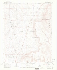
1958 Map of Sentinel Peak NE
USGS Topo · Published 1958About this map
Sleeping Ute Mountain dominates this landscape within the Ute Mountain Indian Reservation, providing a detailed look at the sacred and geological landmarks of the Ute Mountain Ute people in the late 1950s. The survey reveals a terrain defined by high summits like Hermano Peaks and the distinct anatomical features of the mountain, including West Toe and Sentinel Peak (East Toe). Cultural and historical sites are sparsely but significantly noted, such as the Sun Dance Ground located on the northern slopes. The map also traces the vital water sources and early infrastructure essential to the region, from the Aneth Road cutting across the southern plains to numerous water features like Mariano Springs, Chinde Spring, and several unnamed reservoirs. Small details like Ruins and a lone Windmill offer clues to the historical land use and habitation patterns in this corner of Montezuma County.
Find a feature on this map
18 named features on this map. Tap any name to fly to it.
Don’t see what you’re looking for? This feature index may not catch every label — zoom into the map to look around manually.
Map Details
Editions of this 1958 Sentinel Peak NE Map
This is the sole edition of this map. No revisions or reprints were ever made.
Other maps of this area

1956 · Cortez
USGS Topo · 1:250,000

1957 · Moqui SW
USGS Topo · 1:24,000

1957 · Moqui SE
USGS Topo · 1:24,000

1958 · Sentinel Peak NW
USGS Topo · 1:24,000

1958 · Cortez SW
USGS Topo · 1:24,000

1958 · Cortez
USGS Topo · 1:250,000

1959 · Cortez
USGS Topo · 1:250,000

1962 · Cortez
USGS Topo · 1:250,000

1966 · Cortez
USGS Topo · 1:250,000
1966 · Towaoc
USGS Topo · 1:24,000