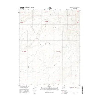
2016 Map of Mariano Wash West
USGS Topo · Published 2016About this map
Mariano Wash and Coyote Wash carve through this corner of Montezuma County, where the high desert landscape is defined by its drainage patterns and a network of tribal routes. The terrain is marked by significant topographical relief, rising from the basin floors toward the northern sections of the map. Modern water management is evidenced by the Landsat-A-1 Reservoir, a lone named impoundment in an otherwise arid expanse. The transportation network is strictly utilitarian, consisting of Bureau of Indian Affairs routes like Indian Rte 201 and Indian Rte 233 that navigate the ridges and valleys. Other watercourses such as Marble Wash and E Mc Elmo Cr suggest a landscape shaped by seasonal flow, where the Public Land Survey System grid overlays a complex natural relief of canyons and washes.
Find a feature on this map
19 named features on this map. Tap any name to fly to it.
Don’t see what you’re looking for? This feature index may not catch every label — zoom into the map to look around manually.
Map Details
Editions of this 2016 Mariano Wash West Map
This is the sole edition of this map. No revisions or reprints were ever made.
Other maps of this area

1886 · Abajo
USGS Topo · 1:250,000

1892 · Abajo
USGS Topo · 1:250,000

1893 · Abajo
USGS Topo · 1:250,000

1956 · Cortez
USGS Topo · 1:250,000

1957 · Moqui SW
USGS Topo · 1:24,000

1957 · Moqui SE
USGS Topo · 1:24,000

1958 · Sentinel Peak NW
USGS Topo · 1:24,000

1958 · Sentinel Peak NE
USGS Topo · 1:24,000

1958 · Cortez
USGS Topo · 1:250,000
1958 · Aneth 1 SE
USGS Topo · 1:24,000