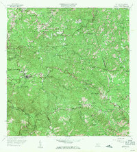
1960 Map of Maricao
USGS Topo · Published 1971About this map
The town of Maricao and the neighboring settlement of Pueblo Nuevo serve as the central hubs for this mountainous region of western Puerto Rico. A significant network of named haciendas, such as Hacienda San Antonio, Hacienda Delicias, and Hacienda Santa Rita, are distributed throughout the steep valleys of the Cordillera Central. These agricultural estates signify the enduring legacy of the plantation economy in the mid-20th century, even as modern infrastructure like the Torre de Observacion and several radio antennas appear on the high ridges.
Find a feature on this map
93 named features on this map. Tap any name to fly to it.
Don’t see what you’re looking for? This feature index may not catch every label — zoom into the map to look around manually.
Map Details
Editions of this 1960 Maricao Map
3 editions found
Other maps of this area

1937 · San German
USGS Topo · 1:25,000

1937 · Sabana Grande
USGS Topo · 1:25,000

1938 · Alto Sano
USGS Topo · 1:20,000

1938 · San Sebastian
USGS Topo · 1:20,000

1941 · San German
USGS Topo · 1:30,000

1941 · San Sebastian
USGS Topo · 1:30,000

1941 · Sabana Grande
USGS Topo · 1:30,000

1941 · Rosario
USGS Topo · 1:30,000

1942 · Central La Plata
USGS Topo · 1:30,000

1942 · Rosario
USGS Topo · 1:30,000