1960 Map of Maricao
USGS Topo · Published 1961About this map
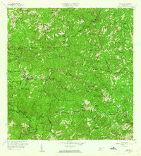
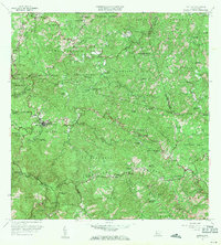
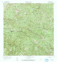
Maricao and its surrounding mountain barrios serve as the centerpiece of this 1960 survey, illustrating a landscape defined by traditional agricultural estates and high-elevation terrain. Numerous haciendas, such as Hacienda Lealtad, Hacienda Ballester, and Hacienda Santa Rita, are scattered across the slopes, marking the enduring footprint of the region’s coffee and sugar history. The town center and nearby Pueblo Nuevo are situated near the headwaters of the Rio Maricao, surrounded by a dense network of mountain streams like the Rio Prieto and Rio Guaba.
Find a feature on this map
101 named features on this map. Tap any name to fly to it.
Don’t see what you’re looking for? This feature index may not catch every label — zoom into the map to look around manually.
Map Details
Editions of this 1960 Maricao Map
3 editions found
Other maps of this area

1937 · San German
USGS Topo · 1:25,000

1937 · Sabana Grande
USGS Topo · 1:25,000

1938 · Alto Sano
USGS Topo · 1:20,000

1938 · San Sebastian
USGS Topo · 1:20,000

1941 · San German
USGS Topo · 1:30,000

1941 · San Sebastian
USGS Topo · 1:30,000

1941 · Sabana Grande
USGS Topo · 1:30,000

1941 · Rosario
USGS Topo · 1:30,000

1942 · Central La Plata
USGS Topo · 1:30,000

1942 · Rosario
USGS Topo · 1:30,000