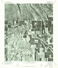
1971 Map of Maricopa
USGS Topo · Published 1972About this map
Maricopa and the nearby community of Ak Chin center this orthophotomosaic, captured during the early 1970s. This aerial perspective reveals a landscape defined by an intensive grid of irrigated agricultural fields that contrast sharply with the desert terrain to the north. The winding course of Vekol Wash cuts across the western portion of the sheet, illustrating the natural drainage patterns that interact with the local road and rail infrastructure. As an orthophotoquad, this map provides an unfiltered look at the actual land usage and settlement patterns in Pinal County during a period of agricultural development, showing the precise footprint of buildings and homesteads before later twentieth-century suburban expansion shifted the character of the region.
Find a feature on this map
3 named features on this map. Tap any name to fly to it.
Don’t see what you’re looking for? This feature index may not catch every label — zoom into the map to look around manually.
Map Details
Editions of this 1971 Maricopa Map
This is the sole edition of this map. No revisions or reprints were ever made.
Other maps of this area

1913 · Maricopa
USGS Topo · 1:62,500

1914 · Gila Butte
USGS Topo · 1:62,500

1915 · Maricopa
USGS Topo · 1:62,500

1917 · Gila Butte
USGS Topo · 1:62,500

1922 · Casa Grande
USGS Topo · 1:62,500

1924 · Casa Grande
USGS Topo · 1:62,500

1946 · Antelope Peak
USGS Topo · 1:62,500

1948 · Antelope Peak
USGS Topo · 1:62,500

1952 · Maricopa
USGS Topo · 1:24,000

1952 · Sacaton Butte
USGS Topo · 1:24,000