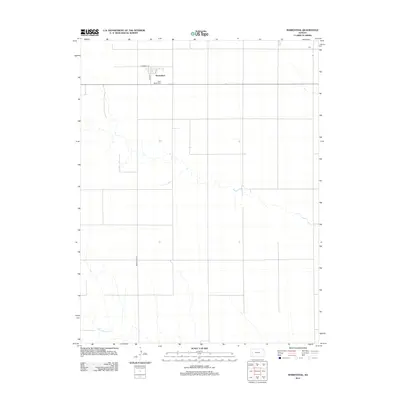
2012 Map of Marienthal
USGS Topo · Published 2012About this map
The unincorporated settlement of Marienthal serves as the central hub of this High Plains landscape, situated at the intersection of local routes like Co Road O 1/2 and N 3rd St. The agricultural character of Wichita County is evident in the rectilinear grid of section roads that define the terrain, leading toward the smaller community of Hess to the northeast. Along the southern edge of the townsite, Saint Mary's Cem provides a focal point for local genealogical interest, documenting the families who settled this portion of the Kansas prairie. Further south, the intermittent course of White Woman Cr winds through the fields, illustrating the natural drainage patterns of the region. The map captures a moment of modern rural life where the vast open spaces are navigated by a precise network of thoroughfares such as Marienthal Rd.
Find a feature on this map
8 named features on this map. Tap any name to fly to it.
Don’t see what you’re looking for? This feature index may not catch every label — zoom into the map to look around manually.
Map Details
Editions of this 2012 Marienthal Map
This is the sole edition of this map. No revisions or reprints were ever made.
Other maps of this area

1939 · Pence
USGS Topo · 1:62,500

1941 · Modoc
USGS Topo · 1:62,500

1941 · Pence
USGS Topo · 1:62,500

1951 · Modoc
USGS Topo · 1:62,500

1955 · Scott City
USGS Topo · 1:250,000

1958 · Scott City
USGS Topo · 1:250,000

1968 · Russell Springs 3 SE
USGS Topo · 1:24,000

1970 · Leoti
USGS Topo · 1:24,000

1970 · Lydia
USGS Topo · 1:24,000
1976 · Modoc SW
USGS Topo · 1:24,000