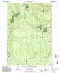
1994 Map of Marion Forks
USGS Topo · Published 1998About this map
Marion Forks serves as the central hub of this 1994 survey, situated where the North Santiam River meets Marion Creek. This area of the Cascades is defined by its water resources and forest management infrastructure, notably featuring the State Fish Hatchery and a complex Penstock system near the forks. The landscape is a network of high-elevation basins and peaks, including Saddle Mountain and Turpentine Peak, dotted with numerous alpine lakes like Nan-Scott Lake and Green Lake. To the east, the boundary of the Mount Jefferson Wilderness transitions into a more secluded backcountry, where the Marion Mountain Lookout House once monitored the surrounding Willamette National Forest. This map documents a specific moment in the management of the Santiam canyon, balancing industrial forestry needs with protected wilderness areas and the recreational draw of the high-country meadows such as Big Meadows and Twin Meadows.
Find a feature on this map
57 named features on this map. Tap any name to fly to it.
Don’t see what you’re looking for? This feature index may not catch every label — zoom into the map to look around manually.
Map Details
Editions of this 1994 Marion Forks Map
This is the sole edition of this map. No revisions or reprints were ever made.
Other maps of this area

1927 · Mt. Jefferson
USGS Topo · 1:125,000

1929 · Mill City
USGS Topo · 1:125,000

1929 · Three Sisters
USGS Topo · 1:125,000

1930 · Mt. Jefferson
USGS Topo · 1:125,000

1932 · Three Sisters
USGS Topo · 1:125,000

1934 · Mc Kenzie Bridge
USGS Topo · 1:96,000

1940 · Mc Kenzie Bridge
USGS Topo · 1:125,000

1953 · Salem
USGS Topo · 1:250,000

1954 · Salem
USGS Topo · 1:250,000

1955 · Echo Mountain
USGS Topo · 1:62,500