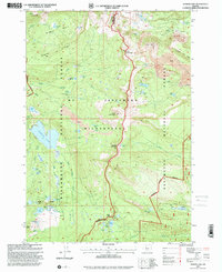
1997 Map of Marion Lake
USGS Topo · Published 2001About this map
The John Swallow Grave stands as a solitary historical marker within the high backcountry of the Mount Jefferson Wilderness, illustrating the human history often hidden in these protected landscapes. This area, straddling the crest of the Cascades between Willamette National Forest and Deschutes National Forest, is defined by its complex volcanic geography and dense network of alpine water bodies. The massive Marion Lake dominates the central terrain, fed by Whiskey Creek and drained by the impressive Marion Falls.
Find a feature on this map
65 named features on this map. Tap any name to fly to it.
Don’t see what you’re looking for? This feature index may not catch every label — zoom into the map to look around manually.
Map Details
Editions of this 1997 Marion Lake Map
This is the sole edition of this map. No revisions or reprints were ever made.
Other maps of this area

1927 · Mt. Jefferson
USGS Topo · 1:125,000

1929 · Three Sisters
USGS Topo · 1:125,000

1930 · Mt. Jefferson
USGS Topo · 1:125,000

1932 · Three Sisters
USGS Topo · 1:125,000

1955 · Bend
USGS Topo · 1:250,000

1957 · Bend
USGS Topo · 1:250,000

1958 · Bend
USGS Topo · 1:250,000

1959 · Three Fingered Jack
USGS Topo · 1:62,500

1959 · Sisters
USGS Topo · 1:62,500

1961 · Whitewater River
USGS Topo · 1:62,500