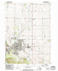
1994 Map of Marion
USGS Topo · Published 1994About this map
Marion serves as the focal point of this Linn County survey, documenting the city's suburban footprint and educational infrastructure in the early 1990s. The map reveals a high concentration of academic institutions, from Kirkwood College and High Sch to neighborhood anchors like Novak Sch and Emerson Sch. Residential growth is bounded by significant green spaces and recreation areas, including Squaw Creek County Park and the Indian Creek Country Club.
Find a feature on this map
68 named features on this map. Tap any name to fly to it.
Don’t see what you’re looking for? This feature index may not catch every label — zoom into the map to look around manually.
Map Details
Editions of this 1994 Marion Map
This is the sole edition of this map. No revisions or reprints were ever made.
Other maps of this area

1887 · Cedar Rapids
USGS Topo · 1:62,500

1888 · Marion
USGS Topo · 1:62,500

1889 · Marion
USGS Topo · 1:62,500

1890 · Anamosa
USGS Topo · 1:62,500

1891 · Mechanicsville
USGS Topo · 1:62,500

1891 · Cedar Rapids
USGS Topo · 1:62,500

1894 · Mechanicsville
USGS Topo · 1:62,500

1900 · Anamosa
USGS Topo · 1:125,000

1901 · Stanwood
USGS Topo · 1:125,000

1903 · Fairfax
USGS Topo · 1:125,000