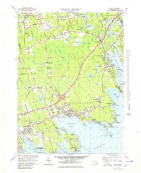
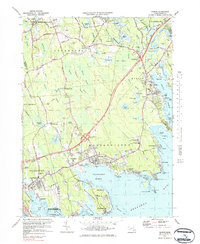
1977 Map of Marion
USGS Topo · Published 1979About this map
Buzzards Bay defines the southeastern character of this coastal survey, where the intricate shorelines of Sippican Harbor and Mattapoisett Harbor meet a landscape heavily defined by the cranberry industry. Scores of Cranberry Bogs are meticulously mapped across the inland lowlands of Rochester and Marion, particularly near Hales Brook and the Sippican River. The spatial organization of the late 1970s is evident in the sprawling Sewage Disposal Ponds and the newly integrated highway system featuring Interchange 25.
Find a feature on this map
95 named features on this map. Tap any name to fly to it.
Don’t see what you’re looking for? This feature index may not catch every label — zoom into the map to look around manually.
Map Details
Editions of this 1977 Marion Map
4 editions found


Other maps of this area

1885 · New Bedford
USGS Topo · 1:62,500

1885 · Middleboro
USGS Topo · 1:62,500

1886 · Falmouth
USGS Topo · 1:62,500

1886 · Plymouth
USGS Topo · 1:62,500

1888 · New Bedford
USGS Topo · 1:62,500

1888 · Falmouth
USGS Topo · 1:62,500

1888 · Middleboro
USGS Topo · 1:62,500

1889 · Plymouth
USGS Topo · 1:62,500

1893 · Middleboro
USGS Topo · 1:62,500

1893 · Falmouth
USGS Topo · 1:62,500