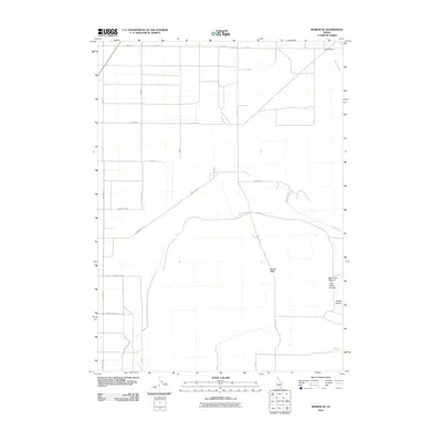
2010 Map of Marion SE
USGS Topo · Published 2010About this map
The high desert landscape of Cassia County, Idaho, is defined by a grid of agricultural and access roads that transition into the rising topography of several canyons. Willow Creek and Land Creek drain from the east, while Mill Creek cuts through the southwest corner, highlighting the critical role of water in this arid environment. Natural water sources like Land Ranch Spring and Bedke Spring were likely vital points for local ranching operations. The transition from the flat agricultural plains, marked by routes such as Layton Rd and Land Ranch Rd, into the more complex terrain of Big Cedar Canyon and Bedke Canyon illustrates the geographic boundary between the cultivated valley and the rugged southern uplands. Significant drainages such as Mackey Wash provide insight into the seasonal hydrology and land use patterns of the region during the early 21st century.
Find a feature on this map
27 named features on this map. Tap any name to fly to it.
Don’t see what you’re looking for? This feature index may not catch every label — zoom into the map to look around manually.
Map Details
Editions of this 2010 Marion SE Map
This is the sole edition of this map. No revisions or reprints were ever made.
Other maps of this area

1954 · Pocatello
USGS Topo · 1:250,000

1958 · Pocatello
USGS Topo · 1:250,000

1964 · View
USGS Topo · 1:24,000

1964 · Kenyon
USGS Topo · 1:24,000

1964 · Burley Butte
USGS Topo · 1:24,000

1968 · Cache Peak
USGS Topo · 1:24,000

1968 · Basin
USGS Topo · 1:24,000

1968 · Marion SE
USGS Topo · 1:24,000
1968 · Oakley
USGS Topo · 1:24,000

1968 · Mount Harrison
USGS Topo · 1:24,000