
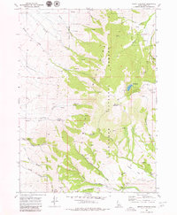
1968 Map of Mount Harrison
USGS Topo · Published 1972About this map
Mount Harrison rises as the central landmark of this high-altitude landscape in southern Idaho, anchored by the Sawtooth Mountains National Forest which covers the eastern half of the sheet. The terrain is defined by a dense network of drainage systems, including Willow Creek, Clyde Creek, and the headwaters of Cassia Creek. Human activity in the late 1960s appears concentrated around resource extraction and recreation, evidenced by Prospects and the Myers Mine in the southwest, while the northern slopes provide for public use at Lake Cleveland and the Brackenbury Campground. A notable hydrological feature is the Gaging Station located along the southern reaches of Cassia Creek, monitoring the water flow through this complex system of canyons like Big Cedar Canyon and Bedke Canyon. The presence of several Jeep Trails suggests a landscape navigated for both utility and access to the numerous springs that dot the mountainsides.
Find a feature on this map
38 named features on this map. Tap any name to fly to it.
Don’t see what you’re looking for? This feature index may not catch every label — zoom into the map to look around manually.
Map Details
Editions of this 1968 Mount Harrison Map
2 editions found
Other maps of this area

1954 · Pocatello
USGS Topo · 1:250,000

1958 · Pocatello
USGS Topo · 1:250,000

1964 · View
USGS Topo · 1:24,000

1964 · Kenyon
USGS Topo · 1:24,000

1968 · Cache Peak
USGS Topo · 1:24,000

1968 · Basin
USGS Topo · 1:24,000

1968 · Marion SE
USGS Topo · 1:24,000

1968 · Elba
USGS Topo · 1:24,000

1968 · Albion
USGS Topo · 1:24,000
1968 · Connor Ridge
USGS Topo · 1:24,000