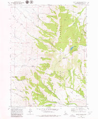
1968 Map of Mount Harrison
USGS Topo · Published 1980About this map
Albion Mountains topography dominates this 1968 field-checked survey, centering on the high elevations of the Sawtooth National Forest. The landscape is defined by a complex network of drainages including Cassia Creek and Clyde Creek, which flow through steep-walled features like Canyon and Boulder Land. Recreation and land management are evident at the high-altitude Lake Cleveland, flanked by the Brackenbury Campground and the Twin Lakes Picnic Area. The map records specific resource extraction and utility points, such as the Myers Mine near the southern boundary and a Gaging Station on the lower reaches of the creek system. A numerous collection of named water sources, including Arrowhead Spring and Land Spring, illustrates the critical importance of water management in this high-desert mountain environment.
Find a feature on this map
38 named features on this map. Tap any name to fly to it.
Don’t see what you’re looking for? This feature index may not catch every label — zoom into the map to look around manually.
Map Details
Editions of this 1968 Mount Harrison Map
2 editions found
Other maps of this area

1954 · Pocatello
USGS Topo · 1:250,000

1958 · Pocatello
USGS Topo · 1:250,000

1964 · View
USGS Topo · 1:24,000

1964 · Kenyon
USGS Topo · 1:24,000

1968 · Cache Peak
USGS Topo · 1:24,000

1968 · Basin
USGS Topo · 1:24,000

1968 · Marion SE
USGS Topo · 1:24,000

1968 · Elba
USGS Topo · 1:24,000

1968 · Mount Harrison
USGS Topo · 1:24,000

1968 · Albion
USGS Topo · 1:24,000