1968 Map of Marion SE
USGS Topo · Published 1972About this map
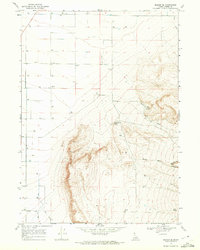
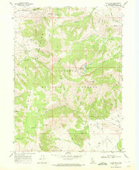
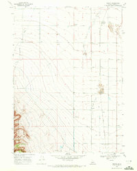
The Oakley Corp Bdy marks the southwestern edge of this landscape, where the agricultural flats of the Snake River Plain meet the rising slopes of the Albion Mountains. Surveyed in the late 1960s, the map reveals a highly developed irrigation and water management system essential for high-desert ranching, indicated by numerous wells and the flow of East Mill Creek toward the settlement. The transition from level ground to high relief is sharp, defined by drainages like Muckey Wash and the steep walls of Big Cedar Can. Small-scale resource extraction is evident near the mountain front, where a Prospect and Mine are situated above Land Ranch Creek. In the more arid eastern reaches, isolated water sources such as Bedke Spring and the seasonal path of Willow Creek highlight the challenges of land use in this part of Cassia County.
Find a feature on this map
14 named features on this map. Tap any name to fly to it.
Don’t see what you’re looking for? This feature index may not catch every label — zoom into the map to look around manually.
Map Details
Editions of this 1968 Marion SE Map
This is the sole edition of this map. No revisions or reprints were ever made.
Other maps of this area

1954 · Pocatello
USGS Topo · 1:250,000

1958 · Pocatello
USGS Topo · 1:250,000
1964 · View
USGS Topo · 1:24,000
1964 · Kenyon
USGS Topo · 1:24,000
1964 · Burley Butte
USGS Topo · 1:24,000
1968 · Cache Peak
USGS Topo · 1:24,000
1968 · Basin
USGS Topo · 1:24,000
1968 · Oakley
USGS Topo · 1:24,000
1968 · Mount Harrison
USGS Topo · 1:24,000
1968 · Marion
USGS Topo · 1:24,000