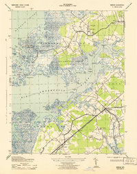
1943 Map of Marion
USGS Topo · Published 1943About this map
Somerset County's coastal landscape is defined by the labyrinthine tidal marshes of Fairmount Neck and Holland Neck during the early 1940s. The settlement of Marion serves as a central hub, where the Pennsylvania Railroad (Crisfield Branch) cuts through the timber and wetlands to connect the inland community with the waterfront. This era shows a deeply integrated relationship between land and water, with small villages like Rumbley and Hopewell positioned alongside intricate waterways like Teague Creek and the Big Annemessex River.
Find a feature on this map
71 named features on this map. Tap any name to fly to it.
Don’t see what you’re looking for? This feature index may not catch every label — zoom into the map to look around manually.
Map Details
Editions of this 1943 Marion Map
This is the sole edition of this map. No revisions or reprints were ever made.
Other maps of this area

1903 · Crisfield
USGS Topo · 1:62,500

1903 · Deal Island
USGS Topo · 1:62,500

1920 · Crisfield
USGS Topo · 1:62,500

1942 · Terrapin Sand Point
USGS Topo · 1:24,000

1942 · Great Fox Island
USGS Topo · 1:24,000

1942 · Marion
USGS Topo · 1:24,000

1942 · Deal Island
USGS Topo · 1:24,000

1942 · Monie
USGS Topo · 1:24,000

1942 · Kingston
USGS Topo · 1:24,000

1942 · Princess Anne
USGS Topo · 1:24,000