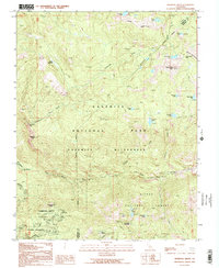
1992 Map of Mariposa Grove
USGS Topo · Published 1995About this map
The Mariposa Grove Big Tree Wilderness serves as the focal point of this late 20th-century survey, showcasing the iconic sequoias of the high Sierras. Landmarks like the Grizzly Giant and the Tunnel Tree are clearly identified, anchoring the southern portion of the map within the broader Yosemite National Park. The landscape is defined by the steep descent of Chilnualna Creek toward Chilnualna Falls and the winding course of the South Fork Merced River.
Find a feature on this map
35 named features on this map. Tap any name to fly to it.
Don’t see what you’re looking for? This feature index may not catch every label — zoom into the map to look around manually.
Map Details
Editions of this 1992 Mariposa Grove Map
2 editions found
Other maps of this area

1897 · Yosemite
USGS Topo · 1:125,000

1900 · Yosemite
USGS Topo · 1:125,000

1901 · Mt. Lyell
USGS Topo · 1:125,000

1903 · Yosemite
USGS Topo · 1:125,000

1904 · Kaiser
USGS Topo · 1:125,000

1909 · Yosemite
USGS Topo · 1:125,000

1912 · Mariposa
USGS Topo · 1:125,000

1947 · Mariposa
USGS Topo · 1:250,000

1948 · Mariposa
USGS Topo · 1:250,000

1953 · Merced Peak
USGS Topo · 1:62,500